
Say “Caribbean vacation” and most people picture a lounge chair, a rum punch, and a stretch of white sand. Hiking rarely enters the conversation. Dominica is quietly out to change that — and its calling card is the Waitukubuli National Trail, a footpath that runs almost the entire length of the island and ranks as the longest hiking route anywhere in the Caribbean.
This isn’t a manicured boardwalk built for postcard selfies. It’s a rugged, end-to-end traverse of one of the region’s wildest and least-developed islands, threading through rainforest, over mountain ridges, past geothermal oddities, and down to the sea. For travelers who want their Caribbean memories to involve sweat and summit views rather than poolside cocktails, few experiences compare.
The Basics: 115 Miles, 14 Segments, One Island
The trail covers roughly 115 miles, which makes it a serious long-distance undertaking by any standard. It starts near Dominica’s northern coast and runs south all the way to Scott’s Head, the dramatic spit of land at the island’s southern tip. Along the way it links Cabrits National Park in the north with the southern coastline, effectively stitching the whole island together on foot.
Here’s the detail that makes the route approachable: it’s broken into 14 separate segments. You don’t have to commit to the full thru-hike. Plenty of visitors come for a long weekend and walk two or three sections, choosing them by scenery, difficulty, or whatever fits the days they have. That modular design is the trail’s secret weapon — it works for both the ambitious multi-week trekker and the casual hiker who just wants one unforgettable day in the forest.
Because Dominica is famously green and sparsely developed, the landscapes shift constantly: dense rainforest gives way to river crossings, then to open ridgelines, then to farmland and coastline. It’s a moving portrait of an island that has protected its wild interior far better than most of its neighbors.
What You’ll Actually See Out There
A few highlights stand out enough to plan a trip around.
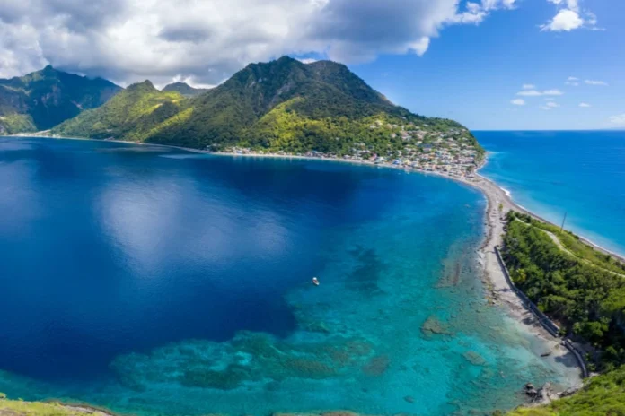
Scott’s Head Peninsula anchors the southern end and may be the single most photogenic spot on the route. Standing on the narrow headland, you can look out at the Caribbean Sea on one side and the Atlantic on the other — a rare meeting of two bodies of water. It sits above Soufrière Bay, a marine reserve teeming with life that doubles as one of Dominica’s best-known diving sites.
Segment 4 offers a detour to the island’s strangest natural wonder: the Boiling Lake, tucked inside Morne Trois Pitons National Park. The lake churns and steams continuously, heated from below by volcanic activity in a flooded fumarole. Ringed by misty peaks and raw volcanic ground, it feels less like the Caribbean and more like another planet. Be warned — reaching it is a strenuous round-trip hike in its own right, not a quick photo stop.
Farther north, Segment 11 runs near Morne Diablotin National Park, prime territory for birdwatchers. The mix of thick forest, rivers, and cultivated land creates ideal habitat for wildlife, including Dominica’s vividly colored native parrots — a sight serious birders travel a long way to catch.
Getting to the Trail
Dominica has a reputation for being hard to reach, and it’s more remote than the cruise-port islands. But access is easier than that reputation suggests. Direct flights connect Miami and several neighboring Caribbean islands to Dominica, so you don’t need a complicated itinerary to get there. Travelers arriving by boat or sailboat have a scenic alternative, and the approach by water is a memorable introduction to the island’s mountainous coastline.
Where to Sleep Along the Way
Lodging exists across much of the trail, but it’s uneven — abundant near some segments, thin near others. Planning around that reality is essential.
A few reliable options:
- Soufrière Guesthouse, near the end of Segment 1, is a practical base for hikers just getting started.
- Le Petit Paradis, close to Segment 3, pairs comfortable rooms with home-cooked meals — exactly what you want after a hard day’s walk.
- Hibiscus Valley Inn and Danglez Bed & Breakfast serve travelers exploring slightly off the main line.
- The town of Picard, near Segment 10, gives you a comfortable overnight stop in the north.
The catch: Segments 8 and 9 have very limited accommodation. If your route runs through them, sort out where you’ll sleep well before you set off rather than hoping something turns up.
Permits, Passes, and What to Pack
Every hiker needs a trail pass from Dominica’s Forestry Division before setting foot on the route. Pricing is refreshingly modest:
- $12 for a day pass covering one or more segments
- $10 group passes
- $40 for a 15-day pass, the smart choice for long thru-hikes
Dominica’s weather is tropical and genuinely unpredictable, and the terrain is demanding, so packing properly isn’t optional. At minimum, bring:
- Offline maps or a GPS device (don’t count on phone signal)
- Reliable rain gear
- A headlamp
- Long pants and comfortable, quick-drying clothing
- A water filtration system for refilling from streams
Anyone planning to camp overnight should add a waterproof tent and proper survival gear to that list. The interior of Dominica is no place to be caught underprepared.
Is It Worth It?
If your idea of a Caribbean trip stops at the resort gate, the Waitukubuli National Trail will feel like a different world entirely — which is exactly the point. Across its 115 miles, it delivers volcanic lakes, two-ocean views, rainforest, rare wildlife, and a level of solitude that’s almost impossible to find elsewhere in the region.
You can sample it in a single afternoon or give it three weeks of your life. Either way, it offers something the postcards never show: a chance to experience the Caribbean on foot, on its own wild terms.